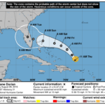
By Lisa Zahner | Last updated 12:15 p.m.TROPICS — At the 11 a.m. advisory, Hurricane Bill had increased in strength from 100 mph sustained winds to 105 mph sustained winds with gusts up to 125 mph. The track has not yet shifted to the north.It appears that Indian River County is in the clear from Hurricane Bill, which became a Category 2 storm overnight, but residents along the Eastern Seaboard will need to wait until probably Friday for Bill to make the predicted turn to the north. In the meantime, Bill is undergoing an eyewall replacement and is set to become a Category 3 storm tonight. Bill is still only about even with the Leeward Islands, so depending on the development of steering currents in the next few days, virtually anything could happen. Bill is on the south side of a ridge “which should steer the hurricane generally west-northwestward for the next couple of days,” according to the National Hurricane Center.The NHC advisory this morning stated, “All track guidance indicates that Bill should turn northward in response to the troughs…but there is some notable spread in where and when.”At the 5 a.m. advisory, Bill was located near latitude 15.5 north and longitude 49.7 west. Bill is moving west-northwest at 17 mph, the northerly turn is expected to occur somewhere between 65 and 70 degrees north, which would put it at Friday or possibly Saturday. Bill’s sustained winds this morning hit 100 mph with gusts up to 120 mph and a minimum pressure of 967 millibars, slightly down from yesterday evening.It seems the entire Eastern United States will be playing a very high-stakes game of Chicken with Hurricane Bill over the next few days, as more than a dozen states could potentially be in the path of this impressive storm.Newspapers in New England and even Canada feature stories this morning about Bill and hurricane preparations. The thought that Vero Beach residents with homes or business interests in the Northeast might have to hop on a plane to secure their property in August is just bizarre, but as the Danbury, Conn. News-Times reports, it has happened more than once before.Click on images to enlarge – computer models from the Weather Underground, 5-day forecast from NOAA.Floyd hit the area in 1999 as a tropical storm. Before that, Gloria brought 60 to 70 mph gusts and the Hurricane of 1938 killed 97 people in Connecticut with 150 mph winds.For Indian River County, the recent A,B,C threat of Ana, Bill and Claudette could serve as a wake-up call to those who have not prepared a disaster kit or a hurricane plan.Explore our new VeroNews.com hurricane center for information on preparedness, evacuation routes and shelter locations.The next advisory by the National Hurricane Center will be at 5 p.m.