
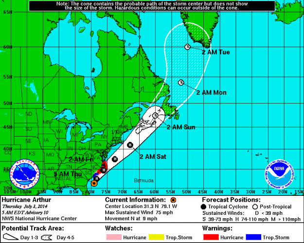
INDIAN RIVER COUNTY — Tropical Storm Arthur has been upgraded to Hurricane Arthur and is headed for the Outer Banks of North Carolina tonight, according to the National Hurricane Center.
The storm has max sustained winds of 75 mph, according to the NHC.
July 2, 5:40 a.m. – INDIAN RIVER COUNTY —The Tropical Storm watch has been canceled for Indian River County, according to the National Weather Service.
A Hurricane Watch has been issued for part of the North Carolina coast as Tropical Storm Arthur moves north, according to authorities. The storm currently has max sustained winds of 60 mph.
July 1, 11:08 p.m. – INDIAN RIVER COUNTY — The National Hurricane Center has upgraded Tropical Depression One to Tropical Storm Arthur, the first of the Hurricane Season.
The storm is currently off the central coast of Florida, according to the report. It’s max sustained winds are at 40 mph. Tropical Storm Arthur is moving northwest at 2 mph.
July 1, 7:13 a.m. – INDIAN RIVER COUNTY — Indian River County is currently under a Tropical Storm Watch for the next 24-36 hours, according to the National Hurricane Center.
Tropical Depression One is drifting towards the Florida Coast today but is expected to stay offshore, according to authorities. Chances for showers and thunderstorms will increase. Gusty winds, lightning and heavy downpours are possible. Some flooding is possible in flood-prone areas.
Main impacts to the area are expected to come from heavy rainfall, according to the Indian River County Operations Center. One to three inches with possible accumulations of up to four or five inches in isolated spots through Wednesday night are possible.
Residents are urged to monitor the progress of this system, have disaster supply kits ready for the hurricane season, and use caution driving.
June 30, 7:21 p.m. – INDIAN RIVER COUNTY — According to a county-wide alert, Indian River County Emergency Management will be closely monitoring the “tropical disturbance” slowly moving inland from about 110 miles East of Melbourne.
“We have been advised by the National Weather Service that environmental conditions are favorable for development and the system is likely to strengthen to a Tropical Depression or Tropical Storm (Arthur) tonight or tomorrow morning. This system is moving southwest at around 5 mph and is expected to turn westward tonight and northward by Wednesday when it will be near the East coast of Florida,” the alert read.
If the storm continues to form, wind gusts may reach between 40-50 mph and 2-3 inches of rain are possible through Wednesday, according to the report.
This article will be updated as more information becomes available.
INDIAN RIVER COUNTY — The National Hurricane Center is reporting increasing thunderstorm activity 125 miles east of Melbourne that could evolve into a tropical depression affecting Indian River County over the next several days.
The storm is expected to effect the coast by Wednesday, and does have the potential to become a tropical cyclone.
Indian River County residents are among those who have been advised to be aware of upcoming tropical storm watches through the next five days.
The National Hurricane Center is expected to deliver an update at approximately 8 p.m. Monday, after a report is returned from an investigating Air Force Reserve aircraft.


