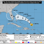
By Lisa ZahnerUpdated 1 p.m. Saturday, August 15Published 11:30 a.m. Saturday, August 15ATLANTIC OCEAN — Tropical depression three has distinguished itself within the cluster of low pressure activity that was Invest 90, which meteorogists had been watching since yesterday. TD Three is expected to be named tropical storm Bill later today.As of the 11 a.m. advisory issued by the National Hurricane Center in Miami, TD Three is located near latitude 11.5 north and longitude 34.0 west and has sustained winds of 35 mph with gusts up to 45 mph. Click on the image to enlarge.The system is moving westward at 17 mph and has a minimum barometric pressure of 1006 millibars (29.7 inches). The 5-day forecast is predicting TD Three to become a Category 1 hurricane by Thursday morning, with winds of about 90 mph.Tropical Stom Ana (pronounced AN-YA) held steady at 40 mph maximum sustained winds (with 50 mph gusts) this morning and was located near latitude 14.3 north and longitude 48.3 west. It is moving westward at 16 mph and has a minimum barometric pressure of 1005 millibars.Dr. Jeff Masters, former Hurricane Hunter and co-founder of the Weather Underground, said in his report this afternoon that Ana is facing conflicting conditions — some favorable to development and others that might cause the storm to break down. He said “the intensity forecast for Ana has higher than usual uncertainty, and I give equal chances that the storm will be a hurricane–or non-existent–four days from now.”The 5-day forecast for Ana has been updated and shifted to the south, now aimed at the upper Florida Keys and Dade County. If this forecast holds, it is good news for Indian River County, as the 5 a.m. forecast had the storm heading straight for the Treasure Coast. The next advisory will be issued by the National Hurricane Center at 5 p.m. Saturday.