
INDIAN RIVER COUNTY — According to the Indian River School District, tonight’s Sebastian River High graduation has been rescheduled to Friday night at 7 p.m.
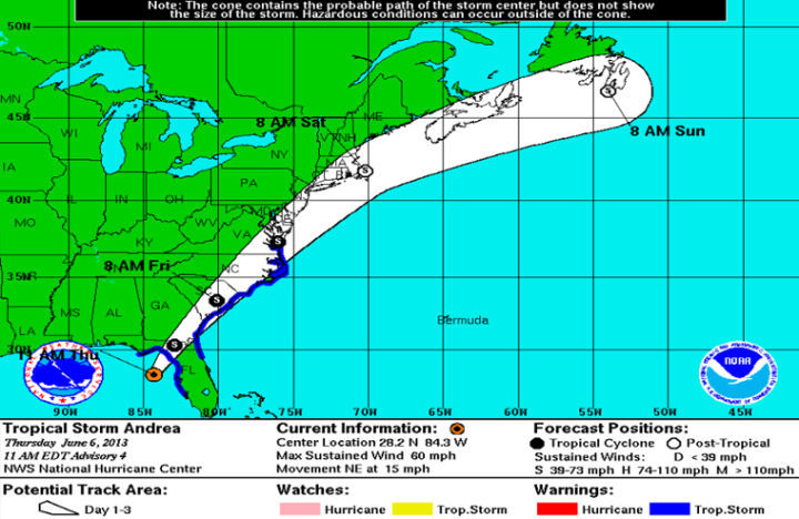
June 6, 12:24 p.m. – INDIAN RIVER COUNTY – Tropical Storm Andrea is expected to cause severe weather in Indian River County.
Today, according to Indian River County Emergency Management, a stronger rain band with more widespread rain and a greater tornado threat will likely reach the area from around midday into the afternoon, and may persist into the early evening.
Additional rainfall of one to three inches is likely, with isolated totals of three to five inches, which may produce minor flooding. Moderate flooding may occur in a few spots where heavy rains persist. Conditions remain favorable for isolated tornadoes, especially when the next rain band moves into the region this afternoon through early evening.
At this time, the graduation for Sebastian River High School is still planned for 7 p.m. this evening. School district officials are closely coordinating a possible delay or rescheduling and those decisions will be made later today and an update will be provided at that time.
Tonight, officials are reporting a most favorable tornado environment is expected to lift north of the region by early evening. Scattered showers and isolated storms may persist well into the evening. One area of concern is the possibility of a rain band trailing south from the tropical storm which may persist across a portion of east-central Florida overnight and into early Friday. If this pattern sets-up, a narrow zone of training showers/storms would locally increase the flood threat.
June 5, 7:09 p.m. – INDIAN RIVER COUNTY — Tropical Storm Andrea has formed in the Gulf of Mexico forcing a tropical storm warning for the west coast of Florida.
A tropical storm watch has been issued for the east coast of the United States from Flagler Beach, Fla., to Surf City, N.C., according to Indian River County Emergency Management.
In the next 24 hours, according to authorities, the area will likely have showers and a possibility of a thunderstorm before 8 p.m.
Then, showers are likely and a possibility of thunderstorms after midnight.
This story will be updated if conditions worsen.


