
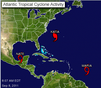
As Hurricane Katia continues to move northeast away from the country’s east coast and farther out into the Atlantic Ocean, Tropical Storms Maria and Nate have formed in the tropics.
Tropical Storm Nate is not expected to impact the U.S., but the future track of Tropical Storm Maria is uncertain.
Though Katia did not have a direct impact on Florida, the Category 1 storm whipped up the surf as she passed by and has caused dangerous rip currents. Indian River County remains under a Rip Current Alert.
Hurricane Katia has been as strong as a Category 3 storm but has since weakened.
Tropical Storm Maria appears to be following a similar path to Katia’s and is currently a little more than 2,000 miles from Miami.
The storm appears “rather disorganized,” according to the National Hurricane Center. A few thunderstorms have popped up on the storm’s west-southwest side.
The National Hurricane Center does not expect Tropical Storm Maria to strengthen within the next 72 hours. After that, though, the storm could gain strength.
Tropical Storm Maria has maximum sustained winds of about 50 mph and is moving westward at 23 mph.
A Tropical Storm Watch has been issued for the Leeward Islands of Antigua, Barbuda, Montserrat, Nevis and Saint Kitts.
Currently, the storm poses no threat to Florida.
In the Gulf of Mexico, Tropical Storm Nate is expected to impact Mexico. Nate formed in the Bay of Campeche and is moving slowly southeast at 1 mph.
The storm is expected to strengthen Friday and already has maximum sustained winds of 45 mph.
A Tropical Storm Warning has been issued for the area of Mexico between Chilitepec and Celestun.
Tropical Storm Nate is expected to produce 2 to 4 inches of rain with isolated areas receiving 8 inches. The storm is also expected to create a storm surge, raising water levels by 1 to 3 feet above normal tide levels.


