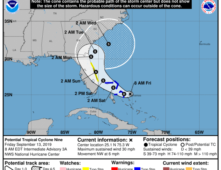
Update: Potential Tropical Cyclone Nine strengthened into Tropical Depression Nine late Friday, according to National Hurricane Center.
Earlier story:
Weather officials Friday issued a tropical storm watch that includes the Treasure Coast ahead of Potential Tropical Cyclone Nine, which was moving northwest toward the northwestern Bahamas.
Potential Tropical Cyclone Nine, which has 30 mph maximum sustained winds, was traveling across the North Atlantic Ocean at 8 mph. The storm could bring heavy rain, tropical storm force winds, rip currents, rough surf and beach erosion to the Treasure Coast this weekend, forecasters said.
A 60 to 70 percent chance of showers was expected for Friday, Saturday and Sunday, weather officials said. The days will have temperatures in the high 80s while the evenings will have temperatures in the high 70s, according to the National Weather Service in Melbourne.
The weekend will have 15 to 20 mph northeast winds with gusts as high as 25 mph.
Potential Tropical Cyclone Nine comes a little more than a week after Hurricane Dorian brushed the southeastern coast of Florida. Since the center of the hurricane stayed offshore, there was little impact to Indian River County.
At 5 AM a Tropical Storm Watch has been expanded north to include Volusia County. Potential TC 9 will slowly strengthen today while moving Northwest toward the Bahamas. pic.twitter.com/T5ZRg89PmG
— NWS Melbourne (@NWSMelbourne) September 13, 2019
Weather forecasters continue to take a close look at Potential Tropical Cyclone Nine. The tropical storm watch, which stretches from Jupiter Inlet to Volusia County, means that tropical storm conditions are possible in those areas within 48 hours.
The storm would have to have a closed off, organized circulation in the system to become a tropical depression and have 39 mph maximum wind speeds to become a tropical storm, National Weather Service in Melbourne Meteorologist Derrick Weitlich said.
“Residents should monitor the forecast closely. It could make landfall or stay offshore,” Weitlich said. “The current weather models have (the storm) staying offshore, but there’s still some uncertainty with that.”


