


Afternoon Update Nov. 10, 2022:
Hurricane Nicole made landfall on the Treasure Coast overnight, but was downgraded to a tropical storm soon after, weather experts said. Nicole swirled over Hutchinson Island, just south of Vero Beach, about 3 a.m. Thursday and steadily weakened as it moved northwest toward central Florida, National Weather Service in Melbourne Meteorologist Melissa Watson said.
The storm flooded several streets and areas in Vero Beach, including Royal Palm Boulevard at the Indian River Boulevard intersection, the eastbound lanes on the Alma Lee Loy Bridge and MacWilliams Park and Boat Ramp, according to Vero Beach police. The Alma Lee Loy Bridge remains closed, officials said.
Nicole has brought 1.90 inches of rainfall to the Vero Beach area since Tuesday, National Weather Service in Melbourne Meteorologist Jessie Smith said. More than 3,000 Indian River County residents were without power Thursday evening, according to the Florida Power & Light Co. power outage map.
The storm was moving northwest at 16 mph with 50 mph maximum sustained wind speeds, according to a 10 a.m. Thursday advisory from the National Hurricane Center. The storm was expected to bring strong winds, storm surge and heavy rains across west central Florida, officials said.
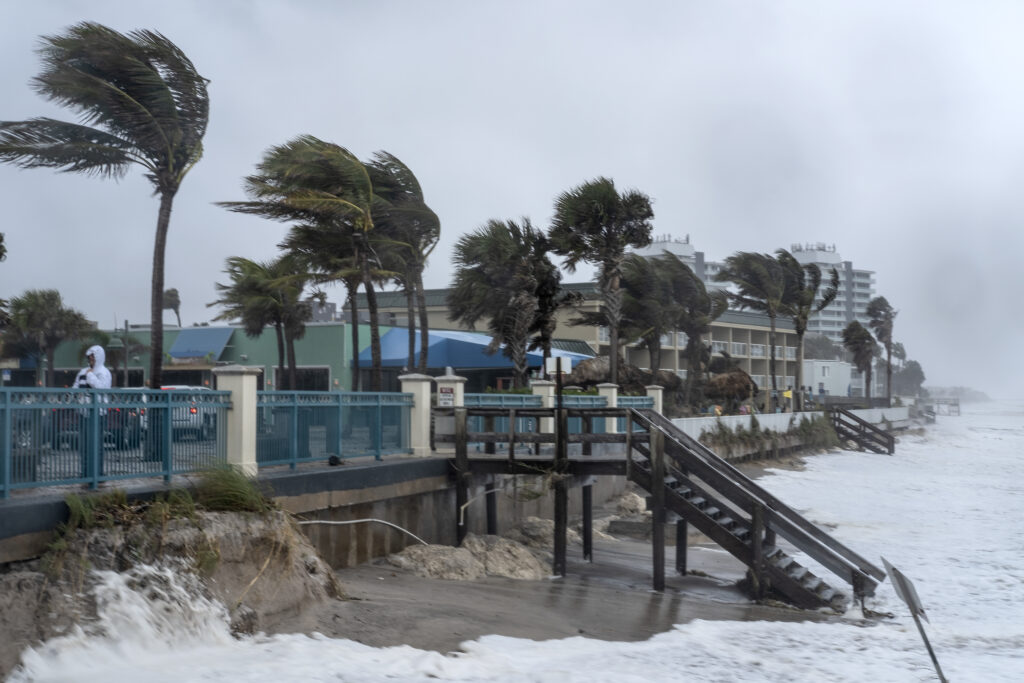
Strong wind gusts up to 35 mph made their way into Indian River County Wednesday, sending water from the Atlantic Ocean up to the wooden access stairways leading to the beaches.
Indian River County government officials issued voluntary evacuations Wednesday for areas east of U.S. 1 including the Barrier Islands, low-lying flood prone areas, residents with mobile homes or vulnerable housing and people with special medical needs. Anyone who wants more information on the storm can call the Citizens Information Line at 772-226-4000.
Evening Update Nov. 9, 2022:
Nicole strengthened from a tropical storm into a hurricane Wednesday evening as it swirled closer to Florida’s east coast, according to the National Hurricane Center’s 6 p.m. advisory. Nicole was expected to make landfall on the Treasure Coast between midnight and 2 a.m., meteorologists said.
“We’re thinking (it will land) between St. Lucie County and Martin County,” National Weather Service in Melbourne Meteorologist Zachery Law said.
Indian River County Emergency Management Coordinator Ryan Lloyd said the track for Nicole shifted further to the south.
“Indian River County will be on the northern part of the storm which will be the worst weather,” Lloyd said during a 2:30 p.m. news conference held at the Indian River County Emergency Operations Center. “We continue to tell our residents to be prepared for the hurricane force winds up to a Category 1.”
Strong wind gusts up to 35 mph made their way into Indian River County Wednesday, sending water from the Atlantic Ocean up to the wooden access stairways leading to the beaches. Nicole was traveling west at 12 mph with 75 mph maximum sustained wind speeds.
Indian River County government officials issued voluntary evacuations for areas east of U.S. 1 including the Barrier Islands, low-lying flood prone areas, residents with mobile homes or vulnerable housing and people with special medical needs. Anyone who wants more information on the storm can call the Citizens Information Line at 772-226-4000.
Evening Update Nov. 8, 2022:
Indian River County will issue voluntary evacuations for certain areas – including the Barrier Islands – Wednesday morning as Tropical Storm Nicole inches closer toward Florida’s east coast, officials said. Nicole continued to gain strength and was expected to become a hurricane sometime Wednesday.
The following areas or groups recommended for voluntary evacuations are:
- areas east of U.S. 1 including the Barrier Islands
- low-lying, flood-prone areas
- residents with mobile homes or vulnerable housing
- people with special medical needs
“The Citizen Information Line will be staffed 24 hours/day for the duration of the storm event if residents or visitors have questions or concerns,” Indian River County government officials said in a statement. “The phone number is 772-226-4000.”
Nicole was moving west at 10 mph Tuesday with 65 mph maximum sustained wind speeds, according to the National Hurricane Center. Tropical storm force winds and hurricane force winds, along with heavy showers, could arrive in Indian River County as early as Tuesday evening, National Weather Service in Melbourne meteorologists said.
The Weather Channel Meteorologist Mike Seidel spoke with Vero Beach City Manager Monte Falls during a live broadcast Tuesday near the beach, just behind the Holiday Inn & Suites at Sexton Plaza. Falls spoke about how the recent storms, including Hurricane Ian, have eroded the town’s beaches.
The Weather Channel Meteorologist @mikeseidel speaks with Vero Beach City Manager Monte Falls Tuesday ahead of #TropicalStormNicole. #VeroNews pic.twitter.com/UwwXd1kc7O
— Nicholas Samuel (@JournalistNickS) November 8, 2022
“We did lose some of the dune from (Hurricane) Ian,” Falls said to Seidel. “We’ll lose more of the dune this evening and the next couple of days.”
Good morning from Vero Beach, Florida, where @mikeseidel is LIVE.
Are you making preparations for #Nicole? Get the latest forecast and alerts on TWC. pic.twitter.com/hYWudWIMUb
— The Weather Channel (@weatherchannel) November 8, 2022
A hurricane warning and a storm surge warning remain in effect for the Vero Beach area until further notice, forecasters said. A flood watch for the area will take effect Wednesday and Thursday.
Morning Update Nov. 8, 2022:
The slow-moving storm Nicole became a Tropical Storm Tuesday as it continues to make its way eastbound toward Florida’s east coast, according to the National Hurricane Center. Indian River County government officials declared a local state of emergency Tuesday morning.
Hurricane warnings were issued for several east coast counties – including Indian River – and remain in effect until further notice.
As the threat has shifted northward, the Hurricane Threat and Impact Graphics have been adjusted. The east central Florida coast should be preparing for the potential of Category 1 hurricane-force winds. Conditions will deteriorate tonight. (2/2) pic.twitter.com/wqiCXTVape
— NWS Melbourne (@NWSMelbourne) November 8, 2022
Nicole, previously a Subtropical Storm, became a Tropical Storm about 10 a.m. Tuesday, National Weather Service in Melbourne officials said. The storm was moving west at 9 mph and carrying 50 mph maximum sustained winds.
A storm surge warning for Indian River County remains in effect until further notice, forecasters said. There will be a 70 percent chance of rain Tuesday evening.
Tropical storm force winds were expected to sweep through the county Wednesday and possibly Thursday, meteorologists said. Hurricane force winds could possibly hit the area Wednesday.
Gov. Ron DeSantis declared a state of emergency Monday for all Florida counties.
Local schools will close Wednesday and Thursday for the approaching storm. Schools were already scheduled to be closed Friday for the Veterans Day holiday.
Three county shelters will open at 7 a.m. Wednesday, according to school district officials.
Those who want more information on the storm can call the citizens hotline at 772-226-4000.
Update:
Local public schools will close Wednesday and Thursday as Subtropical Storm Nicole continues to veer westward toward Florida’s east coast. The School District of Indian River County made the announcement Monday afternoon.
Schools were already scheduled to close Friday for the Veterans Day holiday.
Tweet 1/2 pic.twitter.com/nlMqnmH5vT
— Indian River Schools (@IRCSchools) November 7, 2022
Nicole was traveling northwest at 8 mph with 45 mph maximum sustained winds, according to the National Hurricane Center. The storm was expected to strengthen Tuesday night and Wednesday.
Forecasters said Nicole was expected to grow into a Category 1 hurricane and possibly make landfall on the eastern part of the state. Hurricane watches and storm surge watches remain in effect for several counties – including Indian River – along the eastern coast of Florida.
There will be a 70 percent chance of rain Tuesday night, according to the National Weather Service in Melbourne. Tropical storm force winds and hurricane force winds might sweep through Indian River County Wednesday and Thursday, forecasters said.
Tropical storm force winds carry maximum sustained wind speeds between 39 mph and 73 mph, meteorologists said. Hurricane force winds have maximum sustained wind speeds greater than 74 mph.
Earlier story:
Weather officials issued hurricane watches and storm surge watches for several Florida east coast counties – including Indian River – as Subtropical Storm Nicole takes aim at the state.
— National Hurricane Center (@NHC_Atlantic) November 7, 2022
Nicole – the 14th-named storm of the season – formed into a subtropical storm about 5 a.m. Monday, according to National Weather Service in Melbourne Meteorologist Zachery Law. The storm was expected to strengthen into a Category 1 hurricane and possibly make landfall on the eastern part of the state.
Nicole was veering northwest at 9 mph with 45 mph maximum sustained wind speeds, according to the National Hurricane Center. The center’s 11 a.m. advisory showed Indian River County in the cone of uncertainty.
Subtropical Storm #Nicole Advisory 2: Nicole Remains a Subtropical Storm as it Begins to Turn Northwestward. Hurricane and Storm Surge Watches Issued For the East Florida Coast. https://t.co/tW4KeFW0gB
— National Hurricane Center (@NHC_Atlantic) November 7, 2022
Weather officials issued hurricane watches Monday morning for areas from Volusia County spreading south to Miami Dade County, Law said. Storm surge watches were also in effect for the majority of the southeast Florida coastline.
A coastal flood watch will be issued at 3 a.m. Tuesday for Indian River County and will remain in effect until 7 p.m. Friday, meteorologists said.
Tropical storm force watches were placed in areas from Flagler County going northward, Law said. Subtropical storm force winds carry the same maximum sustained wind speeds as tropical storm force winds, which is from 39 mph to 73 mph, according to weather officials.
The earliest arrival time for tropical storm force winds in our area is 8 a.m. Wednesday, according to Law.
“We anticipate hurricane or tropical storm force winds within 36 hours,” Law said.
This story will be updated.