
Even for a man who once wiped the Soviet Union off the face of the globe, meeting the President of the United States remains the bigger thrill.
“It was a very special day,” Vero Beach Yacht Club member and retiree Richard Rogers said, “one I’ll never forget.”
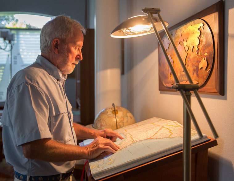
A career cartographer with the National Geographic Society, Rogers’ duties included occasional visits to the White House to make sure maps and charts used by the president were up to date and accurate.
So when President George H.W. Bush summoned him in the early days of his administration – actually, the call came from Rex Scouten, then the White House’s chief usher – Rogers made the three-block walk from National Geographic’s headquarters.
Arriving at the White House, Rogers was escorted to the Map Room, which he described as a “small, cozy, warm room just off the Oval Office.” There, Scouten introduced him to America’s 41st president.
“Rex opened the door and there was President Bush, leaning back in his chair with his jacket and shoes off, his feet propped up on a table and his hands clasped behind his head,” Rogers said. “He was listening to Crystal Gayle’s ‘Don’t It Make My Brown Eyes Blue’ on the stereo, and he had a pleasant smile on his face.
“I remember him saying that she was his favorite country music singer.”
Bush also told Rogers that the Map Room – so named by President Franklin Roosevelt, who used it as his Situation Room during World War II – was his favorite White House chamber, because it provided a quiet place where he could relax and be alone with his thoughts.
“He said he loved to peruse maps, too,” Rogers said, and their shared interest sparked a conversation.
“We talked for a while that day,” he added. “He was a very nice, home-spun guy and I think he enjoyed talking to regular people. I really liked him. He seemed to be very interested in maps and cartography.”
And for more than half a century, maps and cartography have been Rogers’ passion – though, as a young man fresh out of the Navy Seabees in 1958, his plan was to move from the Washington, D.C., suburbs to San Diego and join the marine patrol.
“I wanted to be a water cop,” Rogers said.
Before he could go west, however, his brother responded to an employment ad in the Washington Post for an unnamed company seeking someone with an arts and maps background – using Rogers’ name, education history and Seabee experience as a surveyor and draftsman.
“He applied for me,” Rogers said, “without me knowing about it.”
Not too long afterward, Rogers interviewed for the job, which turned out to be with National Geographic.
“My first job was putting names on maps. From there, I just kept learning and doing more and moving up,” said Rogers, who, along with his wife Annie, relocated to Vero from Solomons, Md., in 2009. The couple lived in the Central Beach area on the island until January 2015, when they moved into a new home in Riverwind.
Rogers spent 36 years with National Geographic, helping create its first “Atlas of the World” in 1963, eventually becoming a map editor and assistant director of cartography before retiring in 1994.
It was in February 1992 that Rogers, armed with 400-grit sandpaper, wiped the Soviet Union off the face of the globe – the 11-foot-in-diameter, 1,550-pound globe on display in Explorer’s Hall at National Geographic’s headquarters in Washington, D.C.
“Having been born in the generation of the Cold War, this is kind of fun,” Rogers told the Associated Press as he sanded away the Soviet Union, which had fractured into the Commonwealth of Independent States, the collection of new nations that replaced the communist monolith.
He later added: “I guess this is the first time in history, at least in our lives, that we’ve seen 17 new nations born all at once. It’s kind of a momentous occasion.”
It was so momentous, in fact, that the AP story and accompanying photograph appeared in hundreds of newspapers around the world, Rogers said.
Thirty years earlier, Rogers had another memorable experience in Explorer’s Hall, putting on an impromptu show for tourists and visitors while astronaut John Glenn was becoming the first American to orbit the Earth.
Using the original version of the 11-foot globe, Rogers projected a bright image of Friendship 7 and, relying on television reports, presented a real-time portrayal of Glenn’s three orbits in his famed capsule.
“Luckily, my timing was just right for his re-entry,” Rogers said. “And the instant it was reported on TV that he had splashed down, I threw a small model of his capsule into the reflecting pond under the globe.”
There was a splash, and then cheers as the crowd saw the capsule floating in the pond.
“There was nothing scientific about it, but the people enjoyed it,” Rogers said. “It was fun for me, too. John Glenn has always been a hero to me.”
More than four decades later, while Rogers and his wife were managing a bed and breakfast in Maryland, friends who worked at General Electric arranged for them to meet Glenn, who was in the area to present an award at the nearby Naval Air Station-Patuxent River.
Glenn and his wife, also named Annie, used the bed and breakfast to freshen up before the award banquet.
“I met my hero,” Rogers said, “and even got a picture with him.”
That was in 2005, long after he retired as a cartographer – a career that produced far more memories than he expected when he first walked through the doors at National Geographic.
Nowadays, GPS has replaced printed maps for many people, but up-to-date maps of a changing world are still necessary to government officials and private citizens, even if they’re digital images transmitted via satellite.
Rogers still enjoys perusing maps, but the only time he draws one now is when someone needs directions and doesn’t have access to a GPS.
“When he does, you should see them,” his wife said. “They’re a lot more extensive than you’d get from the average person.”


