
INDIAN RIVER COUNTY — A continuous line of storms coming off the Atlantic Thursday has dumped more than 4 inches of rain on parts of Indian River County, flooding several roads and parking lots.
The National Weather Service has recorded just over 4 inches of rain at the Vero Beach Municipal Airport between 1 and 4 p.m. today. Another tenth of an inch rain in the hours earlier in the day.
Schools Superintendent Dr. Fran Adams said Thursday afternoon that she was hearing reports from Transportation that some buses had difficulty making their routes taking students home because of flooding on the streets.
Law enforcement reported that there was flooding along US 1 at County Road 510 and at Roseland Road, which required officers to direct traffic through and around the area.
Beachland Boulevard on the barrier island, too, was flooded badly enough to warrant its closure and redirection.
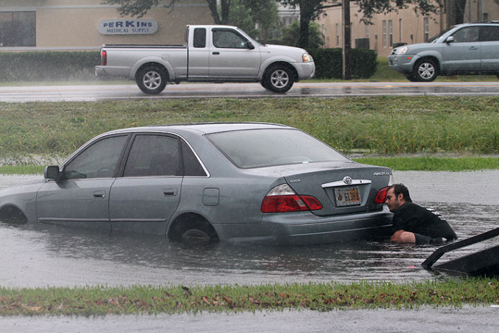
At least one motorist was left stranded due to the heavy rains after making a wrong turn near the Indian River Medical Center. The car became submerged.
“The driver took a wrong turn; that’s what she told me,” said Ron Spada, of Spada’s Total Auto Repair, which arrived on scene to tow the vehicle out.
The National Weather Service issued an urban and small stream flood advisory earlier in the day for eastern Indian River County.
Authorities recommend motorists should deactivate cruise control and slow down in heavy rainfall to reduce the risk of hydroplaning and to leave a safe distance between other vehicles. Do not drive your vehicle into areas where the water covers the roadway. The water depth may be too great to allow your car to cross safely. State law requires headlights to be turned on when windshield wipers are in use. If you come across a flooded road, report it to law enforcement only when it is safe to do so.
Along with issues of flooding, the National Weather Service has noted a high rip current risk for the coast through late Thursday night. According to the agency, the rip current threat will be highest between now and 7:30 p.m. due to tidal effects.
“The brisk onshore winds also will generate rough and pounding waves making the surf zone particularly hazardous today,” the agency wrote in its report.


