
Tropical Storm Isaac has “finally achieved hurricane status” according to the National Hurricane Center.
Max sustained winds are at 75 m.p.h. The storm is currently a Category 1 Hurricane.
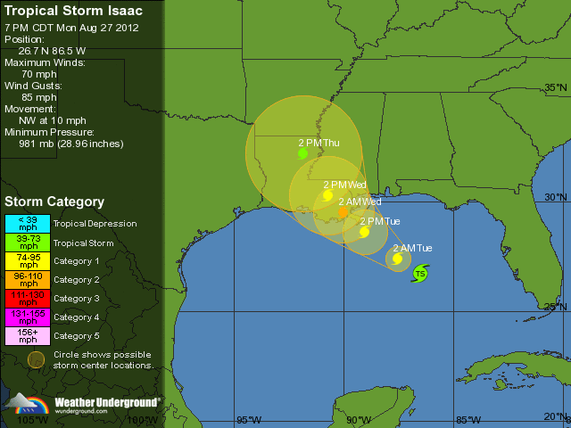
Aug. 27, 9:29 a.m.
Tropical Storm Issac is expected to become a hurricane soon according to the National Hurricane Center.
A significant storm surge and flood threat is expected along the northern Gulf Coast.
The maximum sustained winds are 70 m.p.h. and is only moving at a speed of 10 m.p.h.
Aug. 27, 7:11 a.m.
INDIAN RIVER COUNTY – The Tropical Storm Warning has been lifted for Indian River County but a Tornado Watch is still in effect until 9 a.m.
At 5 a.m. Isaac was strengthening and moving toward the Louisiana coast. They are currently under a Hurricane Warning.
Aug. 26, 4:10 p.m.
INDIAN RIVER COUNTY – Tropical Storm Isaac has attracted surfers with but closes South Beach to swimmers Sunday afternoon. The surfers called the waves “epic.”
Lifeguards though, were forced to call the Vero Beach Police Department, because surfers were venturing into the swimming area. According to the lifeguard on duty, because of a city ordinance, surfers are not allowed in the swimming area.
Assistant Fire Chief Brian Burkeen was not aware of other closures to Indian River County beach swimming areas. An email to City Manager Jim O’Connor has been placed for further information.
Isaac has not strengthened according to the National Hurricane Center.
According to wunderground.com wind gusts are at 75 m.p.h and is sustaining winds at 60 m.p.h.
As of the last conference call, that included local emergency personnel, schools will also not be affected tomorrow.
Aug. 26, 1 p.m.
INDIAN RIVER COUNTY – According to Assistant Fire Chief Brian Burkeen, after an internal county staff meeting, all county offices will be open tomorrow.
Isaac is currently lashing South Florida and the Keys with sustained winds of 65 m.p.h.
Aug. 25, 8:15 p.m.
INDIAN RIVER COUNTY – Isaac is still a strong Tropical Storm, inching up toward Hurricane status with sustained maximum winds of 65 mph at the 5 a.m. Sunday advisory, up from 60 mph at the 11 a.m. advisory.
The barometric pressure inside the storm has dropped from 997 millibars Saturday night to 995 millibars at 5 a.m., indicating that Isaac is poised for further intensification on Sunday.
Over the past eight hours, the five-day forecast track of Isaac, as determined by the National Hurricane Center and various computer models, has shifted westward. This development takes Indian River County farther away from the predicted path of the center of the storm, but places the Gulf Coast states in the path of the large, wet storm.
Isaac remains rather disorganized, but meteorologists expect the system to attain more of a structure as it continues to move across the warm waters south of the Florida Keys. The first rain bands have been hitting the Keys since Saturday morning and the center of Isaac is expected to move over Key West sometime Sunday afternoon. The storm is moving northwest at 18 mph, slightly more slowly than its 21 mph forward speed Saturday evening.
Indian River County remains under a Tropical Storm Warning, as most of the state of Florida is under some kind of Hurricane or Tropical Storm watch or warning. County officials have warned of windy conditions, localized flooding, rough surf and the potential for severe thunderstorms and tornadoes over the next day and a half.
The next update will be posted at 8 a.m., or shortly thereafter.
Aug. 25, 8:07 p.m.
INDIAN RIVER COUNTY – There was no significant change in the speed, intensity or direction of Tropical Storm Isaac from the 5 p.m. Saturday advisory of the National Hurricane Center.
At the latest update, maximum sustained winds were 60 mph with gusts up to 70 mph. Isaac was heading northwest at 20 mph with a barometric pressure of 997 millibars.
The tropical system is passing over very warm water, creating conditions conducive to Isaac strengthening into a hurricane in the next day or so, according to hurricane experts. The storm is off the coast of Cuba, headed northwest toward the Florida Keys.
Indian River County is under a Tropical Storm Warning and county emergency officials have issued alerts warning residents of gusty conditions, heavy and dangerous surf, small craft advisories and potential localized flooding from the several inches of rain expected in the next 48 hours. Tornadoes and lightning are also potential risks as the large storm moves across Florida.
No specific protective measures are being prescribed by county officials and no evacuations are expected. Common-sense precautions such as bringing in lawn furniture and securing lightweight outdoor items such as trash cans is recommended. Local residents should also be prepared for potential localized power outages.
Monroe, Miami-Dade, Broward and even Palm Beach counties have closed facilities and cancelled scheduled activities. A few events in Indian River County have been cancelled or postponed, including the Special Olympics competition scheduled for this weekend.
The next update, if there are any developments, will be at 11 p.m. or shortly thereafter.
Aug. 25, 5:18 p.m.
INDIAN RIVER COUNTY – Tropical Storm Isaac has moved over Cuba and is now in open water. At the 5 p.m. Saturday update from the National Hurricane Center, the storm still had maximum sustained winds of 60 mph with gusts up to 70 mph.
The barometric pressure decreased slightly when it was measured by the Hurricane Hunters this afternoon, down from 1000 millibars to 997 millibars, signaling that the storm may be strengthening. The forward speed has increased slightly to 21 mph., still in a northwesterly direction.
The Indian River County Emergency Services notice at 5:08 p.m. Saturday stated, “Deteriorating weather conditions will first begin to spread across east-central Florida around midday Sunday (Okeechobee and Treasure Coast), with the most widespread or significant impacts expected from late Sunday afternoon through late Monday afternoon.
“We can expect sustained winds of 40 to 50 mph with 50 to 60 mph gusts. There are no evacuations anticipated at this time. Isolated tornadoes are also possible. Please monitor the progress of the storm for any changes.”
The next update will be at 8 p.m. or shortly thereafter.
Aug. 25, 2:10 p.m.
INDIAN RIVER COUNTY — Local residents have already experienced some rain associated with Tropical Storm Isaac, but as the system approaches Florida waters, Indian River County will begin to feel the first of Isaac’s winds later today.
Conditions will become breezy today (15 to 20 mph, with gusts 25 mph) and windy tonight (20 to 25 mph, with gusts 30 mph), according to a recent update from Indian River County Emergency Management.
“Heavy rainfall due to the expected slow motion of Isaac will produce areas of localized flooding. Significant flooding is not expected. Flooding along the St. Johns River is not expected. The smaller rivers and creeks will be looked at closer tomorrow morning. A farther west track away from the peninsula would significantly lessen the threat for heavy rainfall, while any shift east would increase the threat,” the local notice stated.
At the National Hurricane center’s 2 p.m. Saturday update, Isaac’s maximum sustained winds were unchanged at 60 mph, with gusts to 70 mph.
The storm, which is moving across the eastern tip of Cuba, is predicted to be a Category 1 hurricane (74 to 95 mph) when it reaches the Florida Keys and then to strengthen over warm waters in the Gulf of Mexico and reach Category 2 (96 to 110 mph) status as it approaches the Florida Panhandle.
The next update will be at 5 p.m. or shortly thereafter.
Aug. 25, 11:52 a.m.
INDIAN RIVER COUNTY – Indian River County is now under a tropical storm warning as Tropical Storm Isaac approaches.
Saturday at 11 a.m. the max sustained winds were still 60 m.p.h.
The storm is predicted to become a Category One hurricane when the eye reaches Key West.
Aug. 25, 7:35 a.m.
INDIAN RIVER COUNTY – The southwestern coast of Florida is now under a hurricane warning.
Saturday at 5 a.m. the max sustained winds were 60 m.p.h.
Aug. 24, 11:18 p.m.
INDIAN RIVER COUNTY – Indian River County is presently under a tropical storm watch.
Tropical Storm Isaac is now getting better organized according to the National Hurricane Center. Friday at 11 p.m. the max sustained winds were 70 m.p.h.
The storm is now moving toward Haiti.
Aug. 24, 11:00 a.m.
INDIAN RIVER COUNTY – Tropical Storm Isaac is now strengthening as it moves northwestward toward the southern coast of Hispaniola.
Friday at 11 a.m. the max sustained winds were 60 m.p.h.
Aug. 24, 5:06 a.m.
INDIAN RIVER COUNTY – The National Hurricane Center is now calling Tropical Storm Isaac “poorly organized” as it moves westward.
Friday at 5 a.m. the max sustained winds were 45 m.p.h.
The path has also moved farther west removing Indian River County from the projected path of the eye of the storm.
Aug. 23, 8:32 a.m.
INDIAN RIVER COUNTY – The path of Tropical Storm Isaac has shifted slightly west.
According to the 8 a.m. update the path of the eye has shifted more towards the west coast of Florida. But, Indian River County still is in the cone of uncertainty according to the National Hurricane Center.
Haiti and the Dominican Republic are under a hurricane warning.
Aug. 22, 5:55 a.m.
INDIAN RIVER COUNTY – The projected path of Tropical Storm Isaac now includes Indian River County.
The eye of the storm will reach the southernmost part of Florida Monday, 2 a.m., according to the National Hurricane Center.
Wednesday at 5 a.m. the max sustained winds were 45 m.p.h.
Aug. 21, 5:04 p.m. – The Air Force Reserve Hurricane Hunter Aircraft has found that Tropical Depression Nine has developed into Tropical Storm Isaac. At 5 p.m. the max sustained winds were 40 m.p.h.
Tropical depression nine is expected to become Tropical Storm Isaac. The Air Force Reserve Hurricane Hunter Aircraft is currently approaching the depression to assess the storm.
At 2 p.m. the max sustained winds were 35 m.p.h.
This story will be updated as conditions change.


