
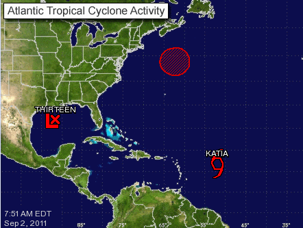
Tropical Depression 13 has formed in the northern Gulf of Mexico off the Louisiana coast and could develop into a tropical storm sometime later today, while Hurricane Katia has been downgraded.
The Gulf depression could become Tropical Storm Lee.
The storm is barely moving – about 1 mph – with maximum sustained winds of 35 mph with higher gusts. A gradual strengthening is forecast during the next 48 hours.
Tropical Storm force winds have been reported on oil rigs north and east of the center of the depression at elevations of a few hundred feet.
Tropical Storm Warnings have been issued for the area between Pascagoula, Miss., west to Sabine Pass, Texas, including New Orleans, Lake Pontchartrain and Lake Maurepas.
A continued slow and possibly erratic motion toward the northwest or north is expected today and Saturday. On the forecast track, the center of the cyclone is expected to approach the coast of southern Louisiana during the weekend.
The depression is expected to produce total rain accumulations of 10 to 15 inches over southern Louisiana, southern Mississippi, and southern Alabama through Sunday with possible isolated maximum amounts of 20 inches.
The large size and slow motion of the cyclone during the next five days is likely to produce a prolonged period of tropical storm conditions and heavy rainfall over portions of the northern Gulf Coast.
Tropical Storm Katia is not expected to strengthen much today. The storm is currently about 750 miles from the northern Leeward Islands.
The storm’s maximum sustained winds are 70 mph, 5 mph less than needed for a Category 1 hurricane. Forecasters predict Katia will regain hurricane status over the weekend.
Katia is moving west-northwest at 15 mph.
The storm has produced a rather large and intense area of thunderstorms overnight, according to the National Hurricane Center, but remains no threat to land at this time.


