
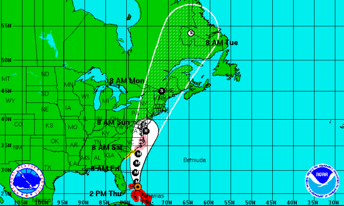
INDIAN RIVER COUNTY — The first bands of wind and rain have begun moving through Indian River County ahead of Hurricane Irene, a Category 3 storm. The eye of Irene is still passing through the Bahamas and is expected to make a turn to the north and start heading up Florida’s east coast overnight and into early Friday.
Though the core of the storm is still expected to stay far out to sea, the wind and rain associated with the storm will be passing over land and creating difficult driving and boating conditions.
Hurricane Irene is expected to approach the coast of North Carolina on Saturday.
The storm currently has maximum sustained winds near 115 mph with higher gusts and is expected to continue to strengthen throughout today and into the night.
Hurricane force winds extend outward up to 70 miles from the center and tropical storm force winds extend outward up to 290 miles.
Indian River County, including several other coastal counties on Florida’s east coast, remains under several advisories. Such advisories include High Winds, Rip Currents, and Squalls.
Below are the advisories from the National Weather Service:
Wind Advisory Alert:
Wind advisory in effect for all of east central Florida today – northeast winds will increase today as major Hurricane Irene tracks over the northwest Bahamas then moves north well offshore the Florida east coast tonight.
- Wind advisory in effect from 10 a.m. this morning to 8 p.m. this evening. Winds will increase in east central Florida. Sustained winds will increase to near 25 mph with occasional gusts of 35 to 40 mph possible. A wind advisory means that winds of 25 mph are expected. Winds this strong can make driving difficult, especially for high profile vehicles. Use extra caution.
Rip Current Statement and High Surf Advisory:
Rip current risk in effect through Friday evening. High surf advisory remains in effect until 8 p.m. Friday.
- Waves and surf: Building swells from major Hurricane Irene will churn up large breakers up to 8 to 12 feet at Atlantic Coast beaches today. This will create rough and pounding surf along with a very high danger for strong rip currents at the beaches. Persons are not advised to enter the water as large breakers can easily knock you down and sweep you out into deeper water.
- Timing: Dangerous surf, rip currents and moderate beach erosion will be possible today through Friday associated with the passage of Hurricane Irene well offshore. Dangerous rip currents are expected to persist into this weekend.
- Impacts: The combination of onshore winds and large surf will produce moderate beach erosion near high tide today and Friday. People visiting the beaches today should not enter the surf. Large breakers can knock you down and make you susceptible to being caught in a rip current. Waves crashing across piers and jetties could also make it difficult to stand or walk.
Special Weather Statement:
A significant weather advisory is in effect for strong wind gusts between 40 and 50 mph over southern Brevard County, Indian River County, Martin County, Okeechobee County, and St. Lucie County.
National Weather Service doppler radar indicated squalls moving quickly southwest at 35 to 40 mph offshore the Space Coast and Treasure Coast. The primary threat will be gusty winds of 40 to 50 mph, which can cause unsecured objects to blow around, snap tree limbs or cause power outages. Occasional lightning strikes and torrential downpours will also occur. Seek shelter indoors until the storm passes.
Hurricane Statement:
Hurricane Irene will bring tropical storm force wind gusts in squalls late this afternoon and tonight. Large battering surf will impact the beaches this afternoon into Friday. At 1 p.m. Melbourne International Airport reported a peak wind gust of 37 mph. At 12:42 p.m., an unofficial wind gust of 45 mph was recorded in a passing rain squall along the coast near Vero Beach.
Watches/Warnings:
- For marine interests – A tropical storm warning is in effect for all portions of the east central Florida Atlantic waters from Flagler Beach to Jupiter Inlet out to 60 nautical miles.
- Over land, although Tropical Storm watches or warnings are not in effect for the coastal counties of Brevard, Indian River, St. Lucie, Martin and Volusia counties, impacts from related hazards are still a significant concern. As result, a wind advisory and a high surf advisory are both in effect today, along with a high rip current risk.


