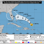
By Nathan McCollumnHurricane Fred reached Category III status Thursday with winds up to 120mph. However, weakening on Friday and overnight has occurred and the current winds are 45 mph. The good news is Fred has reached the ridge weakness and the system is moving through the weakness. Therefore, the only land mass that may be threatened by Fred will be the Azores Islands. The latest satellite images indicate that the ridge weakness has an abundance of wind shear and this will continue to weaken Fred. For Florida, there is no threat from Hurricane Fred. The system is moving northwest at 7 mph. The visible and infrared satellite images indicate shear to the north of Fred. The “feathering” of the northern bands is always a good indicator of shear. The attached water vapor image shows an open ridge with nothing to steer Fred to the west. There is a very high confidence in the overall forecast. Although the forecast shows a west turn in five days, it is expected that this will only be a remnant low and not a tropical system. Therefore, this will be the last advisory on Hurricane Fred.